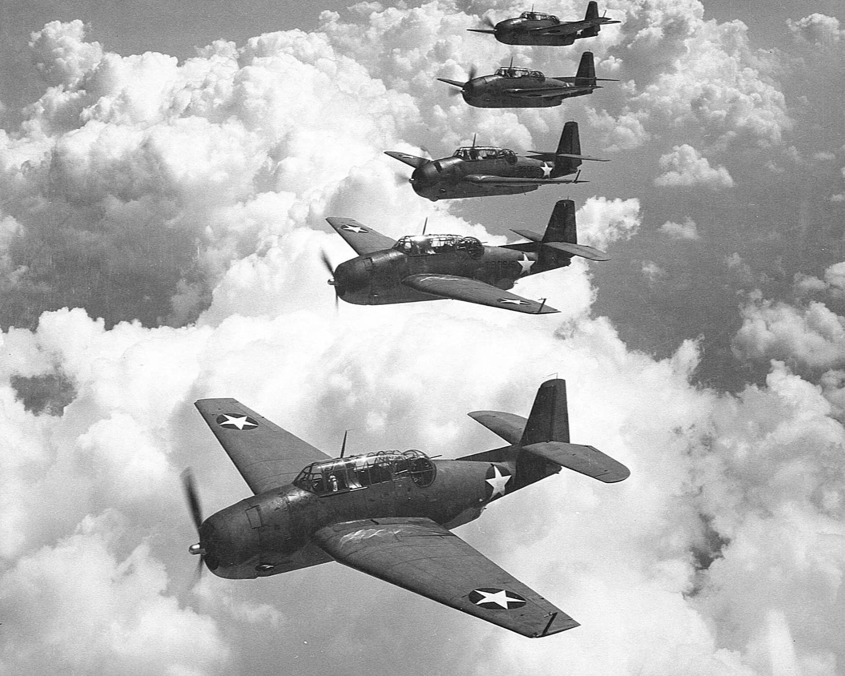
BACKGROUND: U.S. NAVY PHOTO · AVENGERS
CASE 001 · FREE TO READ
Flight 19
Six aircraft. Twenty-seven men. One night. Not a single piece of wreckage was ever found.
Prologue · Wednesday, 5 December 1945
Five Navy bombers took off from Fort Lauderdale on a routine training flight and never came back. Their leader got lost, the fuel ran out after dark, and the rescue plane sent after them exploded. Twenty-seven men vanished without a trace. It became one of the most famous mysteries of the century, and the founding story of the Bermuda Triangle.
6
aircraft lost
27
men never found
300,000
square miles searched
0
pieces of wreckage
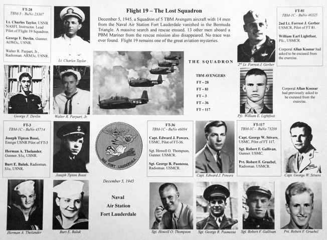
The crews
Fourteen men
Five planes left Fort Lauderdale at 14:10. FT-81 flew with a crew of two. Thirteen more men were lost that night aboard the PBM Mariner sent to find them.
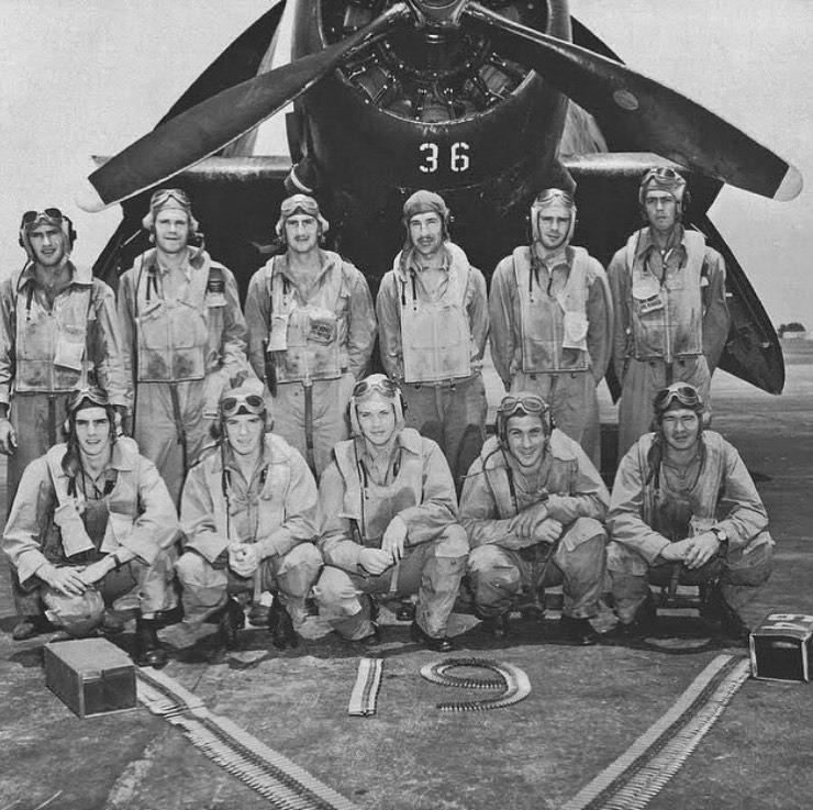
Real photo · 1940s
Navy and Marine aircrew with an Avenger numbered 36.
FT-36 was Capt. Edward Powers's aircraft on Flight 19, and the ammunition belts on the ground spell out “19”. The names of the eleven men and the date are not recorded with the photo, so we have not matched them to the crew list below.
Photo courtesy of the Naval Air Station Fort Lauderdale Museum
FT-28
LEADLt. Charles C. Taylor
Pilot, flight leader
George F. Devlin
AOM3c, USNR · Gunner
Walter R. Parpart
ARM3c, USNR · Radioman
FT-36
Capt. Edward J. Powers
USMC · Pilot
Sgt. Howell O. Thompson
USMCR · Gunner
Sgt. George R. Paonessa
USMCR · Radioman
FT-3
Ens. Joseph T. Bossi
USNR · Pilot
Herman A. Thelander
S1c, USNR · Gunner
Burt E. Baluk Jr.
S1c, USNR · Radioman
FT-117
Capt. George W. Stivers Jr.
USMC · Pilot
Sgt. Robert F. Gallivan
USMC · Gunner
Pvt. Robert P. Gruebel
USMCR · Radioman
FT-81
2nd Lt. Forrest J. Gerber
USMCR · Pilot
Pfc. William E. Lightfoot
USMCR · Gunner
Chapter one · From the radio logs
The flight, minute by minute
Scroll to run the clock. The lines on the map are real output from our model: simulated flights that best fit what the Navy recorded that night.
5 DEC 1945 · EST
14:10
14:10
Navigation Problem No. 1
Five TBM Avengers leave NAS Fort Lauderdale. The plan: fly east to Hens and Chickens Shoals for practice bombing, carry on east, turn north over Grand Bahama, then fly home. Lt. Charles Taylor leads; most of the other men are trainees. The dashed line is the planned route. Each faint line is one of our simulated flights.
Source · Navy Board of Investigation record (NARA M1657)
~15:45
Lost after the last turn
Taylor's compasses have failed. He believes he is over the Florida Keys. Testimony to the Board puts the flight near Walker Cay in the northern Bahamas, nowhere near the Keys. Every decision after this point follows from that mistake.
Source · Baxter testimony, Board record
17:04
Steering for a coast that isn't there
“Going too damn far north”
Believing he is in the Keys, Taylor holds courses that should reach the mainland. From the Bahamas they carry the flight further out over the Atlantic.
Source · Board findings 32–39; Pensacola log
17:19
Turning west
“Flying 270 until I reach field or run out of gas”
Our model puts the turn west at about 16:58 (range 16:49–17:10), earlier than usually assumed and consistent with the Board's finding that it came “prior to 1715.” At 17:24 the order goes out: all planes ditch together when the first drops below 10 gallons.
Source · Model; Board finding 33; Pensacola log
17:50
The radio fix everyone remembers
Shore stations cross their radio bearings: the flight is within 100 miles of 29°15′N 79°00′W. Most retellings stop here and put the planes inside this circle. But the radio kept picking them up for more than an hour after this.
Source · Board finding 28
18:04
The turn that matters
“Fly due east until we run out of gas”
Two minutes earlier: “We may have to ditch any minute.” Then Taylor turns the flight back east, out to sea. This turn is why the ditch area sits far offshore. In our simulations, 87% of flights that kept heading west reach Florida.
Source · Houma and Pensacola HF/DF logs; model
19:04
The last transmissions
“What course are we on now”
The last signals are heard at 19:04. A strong southwesterly, 34–41 knots at their altitude, has been pushing them north-northeast. Fuel runs out between about 19:05 and 19:20. At 19:50 a ship sees flames off Florida: that is the PBM Mariner sent to find them, which exploded with 13 men aboard.
Source · Board findings; ERA5 1945 winds; fuel model
Fuel out
Where they most likely came down
We flew Flight 19 200,000 times, each slightly differently, and kept the versions that match the 1945 record. Each orange dot is where one of them ran dry. The dark zone has an even chance of holding the planes; the light zone, 9 in 10. The centre: 30.1°N, 76.5°W, about 140 nautical miles from the radio fix.
Source · Lazarus Research reconstruction
Chapter two
Why everyone looked in the wrong place
The 17:50 radio fix is the most concrete position in the record, so it became the answer. But it is a snapshot, not an ending. The planes stayed airborne and on the radio until at least 19:04.
In that time Taylor turned the flight back east, out to sea, and a strong southwesterly wind pushed it north-northeast. Fly that hour forward with the 1945 winds and the most likely end point moves about 140 nautical miles from the fix.
The 1945 search barely narrowed it, either. It covered roughly 300,000 square miles of surface looking for floating debris. An Avenger ditched at night in heavy seas sinks in about a minute.
75+ min
of flying after the 17:50 fix
34–41 kt
southwesterly wind at their altitude
~140 nm
from the fix to the most likely centre
~16%
of the probability removed by the 1945 search
Chapter three
What the record told us
The westward turn came around 16:58
Earlier than usually assumed (range 16:49–17:10), matching Board finding 33: “prior to 1715R.”
Fuel ran out just after 19:04
The five-plane fuel model gives about 19:06. Burning 10% faster would mean ditching before 19:04, which the radio record rules out.
A student wingman probably ran dry first
Taylor’s plane hits 10 gallons first in only 38% of runs. Wingmen burned extra fuel holding formation.
Holding west would have saved them
About 87% of simulated flights that kept heading west after 18:04 reach Florida.
They ditched together
The 17:24 order to go down when the first plane hit 10 gallons supports one ditch site, not five scattered ones.
The evening wind was a strong southwesterly
34–41 kt from 210–220° at their altitude, about twice the old ship-based estimate. Miami’s 1945 weather balloon agrees.
The famous sightings don’t change the map
The 19:50 flames were the exploding PBM. Other reported sightings are explained by other flights or search aircraft.
The raw radio bearings were never filed
The Board recorded only the evaluated 17:50 fix, not the individual bearings behind it.
The probability map
Explore it yourself
The most likely area straddles the Blake Escarpment, where the seabed drops from about 900 m to a basin 4–5 km deep. Switch layers on and off.
- Most likely centre
- 30.1°N 76.5°W
- 50% area
- ~6,400 sq nm
- 90% area
- ~20,500 sq nm
- Best 1,000 sq nm
- ~11% of chance
Layers
Coastlines: Natural Earth. Depths: ETOPO1 at 2 arc-minutes. 60 tracks shown.
In memory
The men of Flight 19
Fourteen men left Fort Lauderdale on 5 December 1945, and thirteen more were lost aboard the PBM Mariner sent to find them. Most of the students were still in their teens or early twenties. This case is for them.
FT-28
Lt. Charles Carroll Taylor
USNR · Flight leader, pilot · Nueces County, Texas · age 28
Combat veteran of the carrier USS Hancock, with 2,509 flying hours, 616 of them in Avengers. He had joined NAS Fort Lauderdale as an instructor two weeks earlier.
Biography →George Francis Devlin Jr.
AOM3c, USNR · Gunner · Brooklyn, New York · age 17
Enlisted at 15 under an assumed name and served aboard USS Enterprise before training at Fort Lauderdale.
Biography →Walter Reed Parpart Jr.
ARM3c, USNR · Radioman · Brooklyn, New York · age 18
His family donated his log book, photographs and letters to the museum, where they are on display.
Biography →FT-36
Capt. Edward Joseph Powers
USMC · Pilot · Mount Vernon, New York · age 26
Princeton graduate and the senior officer on the flight. The only husband and father among the fourteen.
Biography →Sgt. Howell Orrin Thompson
USMCR · Gunner · Chicago, Illinois · age 20
Survived the bombing of the carrier USS Franklin in March 1945.
Sgt. George Richard Paonessa
USMCR · Radioman · Mamaroneck, New York · age 28
Third of eight children of Italian immigrants. Flew as an aerial gunner at Kwajalein in 1944.
Biography →FT-3
Ens. Joseph Tipton Bossi
USNR · Pilot · Arkansas City, Kansas · age 20
Studied at the University of Kansas. Turned down a discharge so he could stay in the Navy.
Biography →Herman Arthur Thelander
S1c, USNR · Gunner · Kinbrae, Minnesota · age 19
Joined the Naval Reserve in September 1944 and trained at Jacksonville before Fort Lauderdale.
Burt Edward Baluk Jr.
S1c, USNR · Radioman · Bloomfield, New Jersey · age 19
Enlisted soon after graduating from Bloomfield High School in 1943.
Biography →FT-117
Capt. George William Stivers Jr.
USMC · Pilot · Piedmont, Missouri · age 25
Naval Academy graduate and Marine Raider, cited for gallantry twice on Guadalcanal and once at Tarawa.
Biography →Sgt. Robert Francis Gallivan
USMC · Gunner · Northampton, Massachusetts
Veteran of Guadalcanal, Bougainville and Tarawa. He was due to be discharged the next day.
Biography →Pvt. Robert Peter Gruebel
USMCR · Radioman · Long Island, New York · age 18
Joined the Marines in 1944 and trained in Texas and Miami before Fort Lauderdale.
Biography →FT-81
2nd Lt. Forrest James Gerber
USMCR · Pilot · New Ulm, Minnesota · age 24
Enlisted as a ground Marine in 1942 and earned his wings four months before the flight.
Biography →Pfc. William Earl Lightfoot
USMCR · Gunner · Clayton, New Mexico · age 19
Joined the Marine Corps Reserve at 16. His log book is on display at the museum.
Biography →Explore the method · how the 200,000 flights were scored, the limits, and what a search would take
OpenClose
The method
0
simulated flights, each scored against the 1945 record. The ones that fit are kept. This is Bayesian search theory, the method used to find the Palomares H-bomb, USS Scorpion and Air France 447.
STEP 1
Simulate
Each flight follows the planned route, the recorded turns and the recorded timing. Speed, headings and turn times vary within what the record allows.
STEP 2
Choose the winds by the evidence
ERA5, ECMWF's reconstruction of past weather, matched Miami's 1945 weather balloon and fit the radio evidence about twice as well as older ship-based winds.
STEP 3
Correct for 1945 compasses
Headings were magnetic. Converting with the 1945 magnetic variation improves the fit by about 15–20%.
STEP 4
Score against the record
The 17:50 fix (as an east–west oval), passing over the Bahamas islands Taylor mistook for the Keys, Walker Cay around 15:45, and 100–150 miles off Cape Canaveral at 18:00.
STEP 5
Fix the fuel-out time
All five planes were to ditch when the first reached 10 gallons. Radio was heard until 19:04. Together: fuel-out at 19:05–19:20.
STEP 6
Count the 1945 search
Boxes searched without result lower the odds of ditch points whose debris would have drifted into them.
What this can't tell us
This is a well-argued hypothesis, not a confirmed location, and it has not been peer-reviewed. Where it could be wrong:
- The evening wind is the biggest uncertainty. With older ship-based winds the centre moves about 30 nm south-southeast.
- Fuel capacities differ between manuals, so the model spans 320–340 gallons.
- The 17:50 fix shape is assumed: which stations contributed was never recorded.
- The area has a floor. Five hours of dead reckoning keep each scenario about 4,000–6,000 sq nm wide.
What it would take to find them
Only a seabed survey can close the case
None of the probability lies shallower than 600 m, so it needs robot submarines (AUVs). How deep decides which ones.
Blake Plateau, 600–1,000 m. The cheapest first stage: reachable by mid-depth AUVs.
Escarpment, 1,000–3,000 m. Steep terrain and sonar shadows make it slow. Searched last.
Basin, 3,000–5,000 m. Half the probability, on flat sediment that gives clean sonar returns.
Days of seabed survey
30
Chance of finding the wreck
50%
About 9,900 sq nm covered, searching the most promising cells first. Assumes a robot-submarine fleet sweeping ~330 sq nm a day (the pace of the MH370 search) and 90% detection on flat seabed, 60% on the escarpment. A survey contractor's real figures would replace these.
What could narrow it further
Only new records from 1945: a radar sighting, or the raw radio bearings behind the 17:50 fix. Candidates include Naval Air Station dispatch files, Gulf Sea Frontier dispatches, the deck logs of USS Solomons and her escorts, and the Coast Guard district rescue files. Some may still sit unread in the National Archives.
That was the free case
There are more disappearances on the table
Members get every case file, premium headlines and new cases as we publish them.
Sources
- The Disappearance of Flight 19, NARA M1657 (NAID 146850136)
Board of Investigation record: radio logs, findings, testimony, search plans.
- Board of Investigation findings, transcribed (HyperWar)
Aircraft and pilots.
- ICOADS Release 3.1, December 1945
69 ship weather reports, 24–34°N (NOAA NCEI).
- ERA5 reanalysis (ECMWF), Google public ARCO copy
Winds at 900 hPa, 14:00–20:00 EST, 5 Dec 1945.
- NOAA IGRA v2 radiosondes
Miami and Jacksonville weather balloons, 4–6 Dec 1945.
- IGRF geomagnetic model
1945 magnetic variation (the flight’s headings were magnetic).
- ETOPO1 global relief (NOAA CoastWatch ERDDAP)
Seabed depth bands at 2 arc-minutes.
- NOAA Ocean Exploration: Saipan deepwater surveys
Project Recover’s REMUS 600 surveys to 600 m.
Code and data: github.com/tychocollins/flight19-search. Case file by Tycho Collins, November 2026.